

Online Documentation for SQL Manager for SQL server
Setting spatial index options
Use the Spatial tab to set spatial index options. The settings on this tab are available only if the ![]() Spatial index was selected on the Index tab.
Spatial index was selected on the Index tab.
Spatial indices are enabled in SQL Server 2008 and higher.
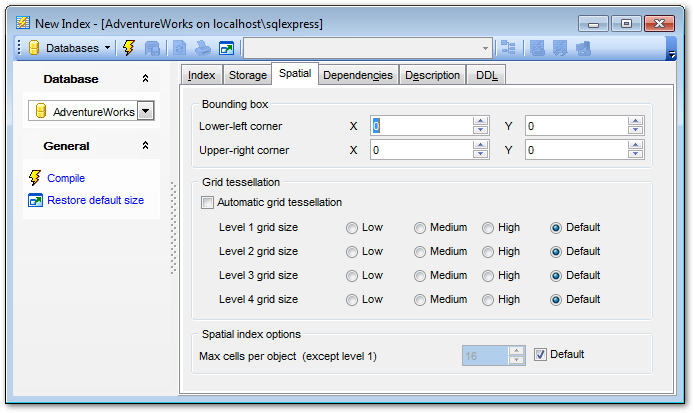
Bounding box
Specifies a numeric four-tuple that defines the four coordinates of the bounding box: the x-min and y-min coordinates of the Lower-left corner, and the x-max and y-max coordinates of the Upper-right corner.
Grid tessellation
Define the density of the grid at each level of a tessellation scheme.
![]() Automatic grid tessellation
Automatic grid tessellation
Check this option to set default values for this data type.
Level n grid size
![]() Low
Low
Specifies the lowest possible density for the grid at a given level. LOW equates to 16 cells (a 4x4 grid).
![]() Medium
Medium
Specifies the medium density for the grid at a given level. MEDIUM equates to 64 cells (an 8x8 grid).
![]() High
High
Specifies the highest possible density for the grid at a given level. HIGH equates to 256 cells (a 16x16 grid).
![]() Default
Default
If the database compatibility level is set to 100 or lower, then the default is MEDIUM on all levels. When the database compatibility level is set to 110 or higher, then the default is an auto grid scheme.
Spatial index options
Max cells per object (except level 1)
Set the number of tessellation cells per object that can be used for a single spatial object in the index by the tessellation process. If the ![]() Default option is checked then the default value is used for the specified tessellation.
Default option is checked then the default value is used for the specified tessellation.


